Automatic Generation of Tourist Maps
Floraine Grabler, Maneesh Agrawala, Robert W. Sumner, Mark Pauly
Abstract
Tourist maps are essential resources for visitors to an unfamiliar city because they visually highlight landmarks and other points of interest. Yet, hand-designed maps are static representations that cannot adapt to the needs and tastes of the individual tourist. In this paper we present an automated system for designing tourist maps that selects and highlights the information that is most important to tourists. Our system determines the salience of map elements using bottom-up vision-based image analysis and top-down web-based information extraction techniques. It then generates a map that emphasizes the most important elements, using a combination of multiperspective rendering to increase visibility of streets and landmarks, and cartographic generalization techniques such as simplification, deformation, and displacement to emphasize landmarks and de-emphasize less important buildings. We show a number of automatically generated tourist maps of San Francisco and compare them to existing automated and manual approaches.
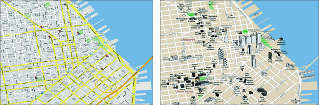
(left) A digital map of San Francisco from Google (www.google.com) marks the location of a few user-chosen landmarks using pushpins. It is impossible for a tourist to recognize buildings without further visual information. (right) A tourist map generated by our system automatically includes contextual landmarks in addition to the category of buildings (i.e. restaurants, shopping, etc.) chosen by the user. Moreover the map depicts building facades so that tourists can more easily identify the buildings.