Automatic Generation of Destination Maps
Johannes Kopf, Maneesh Agrawala, David Bargeron, David Salesin, Michael F. Cohen
Abstract
Destination maps are navigational aids designed to show anyone within a region how to reach a location (the destination). Hand-designed destination maps include only the most important roads in the region and are non-uniformly scaled to ensure that all of the important roads from the highways to the residential streets are visible. We present the first automated system for creating such destination maps based on the design principles used by mapmakers. Our system includes novel algorithms for selecting the important roads based on mental representations of road networks, and for laying out the roads based on a non-linear optimization procedure. The final layouts are labeled and rendered in a variety of styles ranging from informal to more formal map styles. The system has been used to generate over 57,000 destination maps by thousands of users. We report feedback from both a formal and informal user study, as well as provide quantitative measures of success.
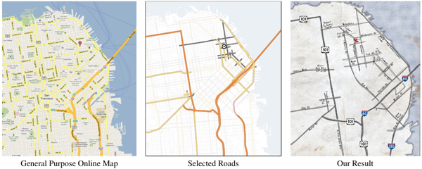
A general purpose online map (from Google Maps) with fixed scale is not an effective destination map because the neighborhood streets disappear. Our system selects a relevant subset of the highways, arterials and residential roads required to reach the destination. It then lays out the selected roads, so that all the selected roads are visible and renders the map in a hand-drawn style.
Research Paper
Additional Links
Bing Implementation of Destination Maps (requires Silverlight, Windows and Internet Explorer).
Additional Results
Analysis of Energy Terms
Johannes Kopf's website for paper